Analysis of existing approaches to risk analyses and calculation method for emergency planning zone used in Italy
Rozbor existujících přístupů k analýze rizik a metoda výpočtu velikosti zóny havarijních plánování v Itálii
Jan Skřínský1, Vilém Sluka2, Martina Pražáková3, Stanislav Malý4
1Energy Research Centre, VŠB - TU Ostrava, 17. listopadu 15/2172, 70833 Ostrava, Czech Republic, jan.skrinsky@vsb.cz
2Department of Major Accidents Prevention, Occupational Safety Research Institute, Jeruzalémská 9, 116 52, Prague, Czech Republic, sluka@vubp-praha.cz
3Department of Major Accidents Prevention, Occupational Safety Research Institute, Jeruzalémská 9, 116 52, Prague, Czech Republic, prazakova@vubp-praha.cz
4Stanislav Malý, RNDr., Department of Major Accidents Prevention, Occupational Safety Research Institute, Jeruzalémská 9, 116 52, Prague, Czech Republic, malys@vubp-praha.cz
Abstract
In the first section we present the analysis of existing approaches to risk analyses in the European Union, in the area of the control of major-accident hazards involving dangerous substances. In the second section we focused on and analyse the index-based deterministic method developed and used for evaluation of emergency planning zone in Italy with respect to Seveso II Directive. The results of the analysis have been used both to evaluate the purpose of the emergency planning zone and to evaluate the criteria proposed for calculation of emergency planning zone distances. Individual steps of the presented emergency planning methodology have been identified, and the two different applications for toxic gas release and explosion have been described. The results obtained allowed us to start a systematic comparison of selected states with index-based method for emergency planning zone calculation in the future.
Keywords: Seveso Directive, control of major accident hazards, emergency planning zone
Abstrakt
V první části příspěvku je prezentována analýza existujících přístupů k analýze rizik ve vybraných státech Evropské Unie v oblasti prevence závažných havárií s přítomností nebezpečných chemických látek. Ve druhé části příspěvku je analyzována deterministická indexová metoda vypracovaná a používaná ke stanovení zón havarijního plánování v Itálii jako nástroj pro splnění požadavků Seveso II Direktivy. Výsledky analýzy byly použity jak ke zhodnocení zóny havarijního plánování, tak k hodnocení návrhu kritérií k výpočtu velikostí zón havarijního plánování. Byly identifikovány dílčí kroky metody ke stanovení zóny havarijního plánování a demonstrována aplikace této metody pro únik vybrané toxické a výbušné látky. Takto získané výsledky nám do budoucna umožnily začít systematicky porovnávat vybrané státy používající indexové metody pro stanovení velikosti zóny havarijního plánování.
Klíčová slova: direktiva Seveso, prevence závažných havárií, zóna havarijního plánování
Introduction and interest
Our interest started in 2008. Baudišová et al. published the critical analysis of determination of emergency planning zones. The main topic of the article is the critical analysis of method used in the Czech Republic at present for the elaboration of zones of emergency plans of industrial enterprises for accidents caused by selected hazardous chemical substances and chemical preparations. The reason for the analysis was author’s experience that the more mechanical application of methodological procedure stated in the Decree of Ministry of the Interior No. 103/2006 Coll. could lead to underestimation or on the other hand overestimation of given risks with regard to the surrounding population. The analysis was made by comparing the result of applications of the mentioned decree with the results obtained by tools of mathematical modelling on the basis of utilization of currently available type limit amounts of chemical substances.
Optimization of emergency planning zone and emergency plans creation based on harmful effects of dangerous chemicals released during major accidents with respect to improvement of civil protection (further referred as OPTIZON). The OPTIZON project deals with the improvement of civil protection level in the Czech Republic. Project covers optimization of emergency planning zones based on using of time parameters, which are characteristic for accidental effects of dangerous chemicals during major industrial accidents and other important physical parameters. Creation of source materials for legislative charge and setting of requirements for selected parts of emergency plans processing is also part of the project.
As one of the first results of this project Baudišová et al published in 2011 the contribution lists several possible approaches for finding the sense, which opens the way to solve problems and expert discussion for all parties concerned. By analyzing the issue of emergency planning zones has been found several serious problems that need to be expertly discussed and are the goals of OPTIZON project. Their common focus is unclear sense of emergency planning zones. Furthermore, both (Baudišová et al., 2011) and (Danihelka et al., 2011) published the contributions about the need of discussion for a change in the determination of the external zone of emergency plans.
The aim of this contribution is to present an overview of the present state of existing approaches to risk analysis in the frame of the emergency planning zone/distance/areas and the calculation method for emergency planning zones used in Italy in the frame of the project OPTIZON.
Previous studies
In the last decade, different methods and tolerability thresholds criteria listed in (Kirchsteiger, 1998) were developed in European countries as can be seen from Figure 1a,b.
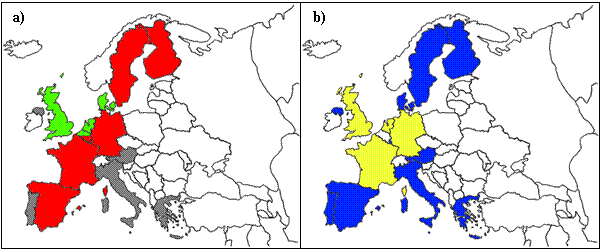
Figure 1: a) Overview of approaches adopted for risk assessment: (1) “consequence oriented” approach (red); (2) "risk oriented" approach (green); (3) "safety distance" approach (Germany, Sweden); (4) approach still being developed (grey); b) Land-use planning criteria and procedures: (1) exists (yellow), (2) being developed (blue)
From the methodological point of view, three approaches adopted for risk assessment can be distinguished in the considered states: (1) the first one focuses on the assessment of consequences of a number of conceivable event scenarios and is typically called "consequence oriented" approach; (2) the second one focuses on the assessment of both consequences and probabilities of occurrence of all possible event scenarios and is called "risk oriented" approach. For a given installation, the "consequence oriented" approach will characteristically show the consequence area for lethal effects and serious injuries resulting from the scenarios assessed, while the "risk oriented" approach will show an area within which there is a given probability of a specified level of harm resulting from all possible accidents. In addition to these two methodological approaches, a third one could also be included, consisting of the determination and use of "generic" distances depending on the type of the activity rather than on a detailed analysis of the specific site. The safety distances adopted this way usually depend on the environmental impact of the industry. It should be noted that the above categories are not mutually exclusive. Each state can be characterized by the approach adopted within the following list of four cases: (1) establishing "generic" distances, mainly based on the environmental impact of the industrial activities (see Germany and Sweden in Figure 1a); (2) the "consequence oriented" approach (see red colour in Figure 1a); (3) the "risk oriented" approach (see green colour in Figure 1a), and (4) arrangements are still being developed (see blue colour in Figure 1b). Furthermore, from Figure 1b it is recognised that there is not unique procedure for all selected states, the political, cultural, structural, technical and other differences being a probable parameter of distinction. Moreover, these procedures should be designed in a way that ensures that technical advice on the imposed risk is available and will be used when decisions are taken. In Europe, any attempt to establish guidelines on emergency planning should certainly take into consideration the national legislation that exists in the presented states and the practices used. Two broad categories of countries can be distinguished: (1) countries which have already established well-structured procedures for taking hazards into account in emergency planning, and (2) countries in which such procedures are under development and no explicit regulations for emergency planning in the vicinity of hazardous installations exist up to now. The various methods and hypotheses used in the course of risk analysis and zone can generate substantial differences. Therefore, the comparison of the numerical emergency planning criteria used in different countries is not sufficient without detail analysis. In the first category (see yellow color in Fig. 1b) the countries with long tradition and experience in handling major hazards are included, such as the Netherlands, United Kingdom, France and Germany. Southern European countries, such as Italy, Greece, Spain and Portugal, belong to the second category, while some other countries such as Denmark are very close in establishing procedures and criteria for land-use planning. Member States of the second category do not show less concern about major hazards but the control of land-use planning in the vicinity of hazardous installations is covered up to now by the legislation for physical planning and consists of relatively simple procedures.
Summary
| Country | "Generic" safety distances based on environmental impact | "Consequence oriented" approach | "Risk oriented" approach | Land-use planning criteria | Arrangements still being developed |
| Austria | X | ||||
| Belgium | X (Walloon) | X (Flemish) | X | ||
| Denmark | X | X | |||
| Finland | X | ||||
| France | X | X | |||
| Germany | X | X | X | ||
| Greece | X | ||||
| Ireland | X | ||||
| Italy | X | ||||
| Luxembourg | X | X | |||
| The Netherlands | X | X | |||
| Portugal | X | ||||
| Spain | X | X | |||
| Sweden | X | X | X | ||
| The United Kingdom | X | X |
Table 1: Brief Overview of the Land-Use Planning Practices in the European Union
Table 1 summarizes classification for each Member State of the European Union (1998). For each country it is indicated whether the "environmental impact", the "risk-oriented" or the "consequence-oriented" approach is followed and whether criteria related with the level of risk or consequences have been adopted or arrangements are still under development or included in the general land-use planning legislation (Kirchsteiger et al., 1998).
As the first result of the previous studies it was found that the selected states ensure that the objectives of preventing major accidents and mitigating the consequences of such accidents are taken into account in their land-use planning policy. What is the role of emergency planning in such preventive measures?
As the second result was found that the classification summarized in Table 1 is from 1998 i.e. out of date. Moreover, in some Member States the risk analysis approaches as well as related criteria were in 1998 under development. What is the actual state of both measures?
The third result is that the land-use planning is summarized only for Member states. What about the planning in other Non-Member European and Non-European states?
The fourth result is that all competent and planning authorities shall set up appropriate consultation procedures to facilitate the implementation of the policies mentioned above (i.e. the emergency planning policies that take into account the major-accident hazards) and as a result set-up appropriate zones/distances/areas.
The fifth result is that was found the possible links between the development of zones for emergency and land-use planning (see 5-7 in Christou, 2007). The land-use planning considerations are often defined as “zones” or “distances”. Requirements to be covered by the external emergency plan are also inherently considered as “areas”, “zones”, or “distances”. There was found no requirement that these zones or the methodology for determining zones or distances have to be the same or different.
ND-USE It should be also noted that the legislative framework of Member States including SEVESO II Directive does not make any attempt to quantify the separation distances in detail. On the contrary, it lets the states and the authorities to quantify them and to decide what distance would be appropriate for each establishment.
In this section, the previous studies for land-use planning in the context of major-accident hazards are summarized in the Table 1. In the next section, example from the application of “consequence based approach” in order to set up the emergency planning zone/distance/area in Italy is given.
The method for calculation of emergency planning zone distances in Italy
Based on the (Linee Guida, 2005), Italy, from the point of view of emergency planning risk assessment, belongs to the countries with the “consequence-oriented” approach (sometimes called the “deterministic approach”). This approach is based on assessment of the consequences of possible accidents, whereas no attempt is made to quantify the “likelihood” of these accidents. The concept behind use of this approach is to avoid tackling of uncertainties related to the quantification of occurrence frequency of these potential accidents.
It should be noted that the assessment of the occurrence frequencies of various accidents is a hard and time-consuming task, and much criticism has been expressed concerning usefulness of the assessed frequencies, given the uncertainty associated with the final estimates. In the next section the emergency planning zones for consequences of major accidents are discussed.
Emergency planning zones
According to the Italian method the boundaries of the affected areas have to be classified according to the maximum acceptable effects to the target. Emergency planning control in Italy is necessary for the area corresponding to the maximum calculated distance for all the scenarios evaluated. This area is divided into three zones with different development restrictions and different thresholds values. The distance for the first “high impact” zone according to the consequences of an accident caused by the hazardous material is calculated as:
![]() (1)
(1)
| DSI | distance of high impact (ital. “sicuro impatto”) | [m] | ||
| MINF | lower value of the range of reference values | [ton] | ||
| MSUP | higher value of the range of reference values | [ton] | ||
| QTOT | actual value of the substance present in the unit of plant | [ton] | ||
| QINF | lower value of the quantity | [ton] | ||
| QSUP | higher value of the quantity | [ton] | ||
Four scenarios involving toxic gas release and corresponding amounts of toxicity affecting people in these areas are considered. Further two examples of calculation of high impact and damage zone distances are given. The objective of the risk assessment procedure in the case of toxic cloud release is the calculation of two distances: (1) The distance, at which the death occurs (corresponding to 50% probability of fatalities); and (2) the distance, at which irreversible health effects occur (corresponding to IDLH). In scenarios involving fire or explosion the affected area is considered to be circular and independent of meteorological conditions. On the contrary, effects of toxic substances depend on weather conditions. However, variability of wind direction is not taken into account, and the corresponding area is again considered circular. It should be noted that any conceivable scenario leading to consequences worse than those of the reference scenarios, might also be used for determination of risk zones. However, scenarios with very small probability are not evaluated. The criteria for land-use planning are those of high mortality and material damages (domino effect) and irreversible effects due to: The stationary thermal radiation (i.e. fire); variable thermal radiation (i.e. BLEVE/fire-ball); instantaneous thermal radiation (i.e. flash-fire); overpressure and missile projection (UVCE/CVE); toxic release (absorbed dose) see Table 2.
| Scenario | Effects | Criteria | |
| High impact zone | Damage zone | ||
| A: BLEVE/fireball | TR, O | fire-ball region | 200 kJ/m2 |
| B: UVCE | O | 0.3 bar | 0.07 bar |
| C: Fire | TR | 12.5 kW/m2 | 5 kW/m2 |
| D: vapor cloud (toxic) | TD | LC50 (30 min, hmn) | IDLH |
| E: vapor cloud (flammable) | TR | LFL | 0.5 x LFL |
Table 2: Endpoint values adopted for emergency planning (Linee Giuda, 2005).
BLEVE= Boiling Liquid Expanding Vapour Explosion; UVCE= Unconfined Vapour Cloud Explosion; TR= Thermal Radiation; TD= Toxic dose; O= Overpressure; MaP= Missile and product projection originating from the explosions; LFL=lower flammable limit.
The criteria for land-use planning (see Table 3) are those of high lethality, initial lethality, irreversible injuries, reversible injuries and material damages (domino effect) due to: stationary thermal radiation (i.e. fire); variable thermal radiation (i.e. BLEVE/fire-ball); instantaneous thermal radiation (i.e. flash-fire); overpressure and missile projection (UVCE/CVE); toxic release (dose absorbed for 30 min by human) (Christou, 2008). As can be clearly seen from the Tables 2-3, Italy belongs to the countries with emergency planning criteria being a subset of land-use planning criteria. In the case study considered in (Lingee Guida, 2005) the two events have been evaluated – the toxic release of chlorine and explosion of ammonium nitrate.
| Scenario | Criteria | ||||
| High lethality | Starting lethality | Irreversible effects | Reversible effects | Damages to structures | |
| 1 | 2 | 3 | 4 | 5 | |
| A: Fire | 12.5 kW/m2 | 7 kW/m2 | 5 kW/m2 | 3 kW/m2 | 12.5 kW/m2 |
| B: BLEVE/Fireball | fire-ball radius | 350 kJ/m2 | 200 kJ/m2 | 125 kJ/m2 | 200-800 m* |
| C: Flash-fire | LFL | 0.5 x LFL | - | - | - |
| D: VCE | 0.3 bar/0.6 bar** | 0.14 bar | 0.07 bar | 0.03 bar | 0.3 bar |
| E: Toxic release | LC50 | - | IDLH | - | - |
Table 3: Endpoint values adopted for land-use planning
BLEVE= Boiling Liquid Expanding Vapour Explosion; UVCE= Unconfined Vapour Cloud Explosion; IDLH=Immediately Dangerous to Life or Health; LFL=lower flammable limit; (*) related to the typology of the tank; (**) open spaces.
| 1 | 2 | 3 | 4 | 5 | 6 | 7 | |
| Substance | Phase | Type of process | Event | Quantity (t) | Factor SDD | Factor F.2 | |
| 50-200 | 200-1000 | ||||||
| Chlorine | Liquefied gas | - | TU | F | F | 4.2 | 4 |
| Ammonium nitrate | Solid | Separate containers | E | C | D | 2 | 1 |
Table 4: Selected scenarios for stability class D
TU= release of toxic effects onto humans; E=explosion; F,C,D= indexes for determination of the distance of high impact as a function of quantity; SDD= factor for determination of the distance of damage; F.2=factor for determination of the distance for meteo class F.2
| Category | Interval (m) |
| C | 50-100 |
| D | 100-200 |
| E | 200-500 |
| F | 500-1000 |
Table 5: Distance as a function of the effects categories.
Toxic release (references for tables taken from Linee Guida, 2005)
We consider a storage tank containing 300 tons of chlorine (liquefied under storage conditions). Determine (1) high impact and (2) damage zone distances for toxic release of chlorine that would affect people in the corresponding area. We proceed by consulting the Table 4 by filling the first 4 columns, respectively: the hazardous substance (column 1: Chlorine), the physical state (column 2: liquefied gas), the type of work performed (column 3: In this case, without specification), and the event, for which the scenario is estimated (column 4: release of toxic effects onto humans - column labeled TU). At this point switch to column 5 by identifying the interval to which the substance falls according to its amount. The intersection of the reference band column with the line containing the case (chlorine, liquefied gas, TU = toxicity to humans identifies the letter corresponding to the category of effects (F). At this point, using the Table 5 of effect categories at the end of the letter F identify 500-1000 meters, within which you need to locate the exact distance to be safe: by applying the expression from the equation 1 we obtain the exact distance relative to the first zone of high impact, where high human lethality is expected. When we enter the corresponding values we will also get the SDD (from ital. Seconda Distanza di Danno, index by which is multiplicating the distance of high impact to obtain the value of the distance of damage) and F (category of effects) factors that we will use for subsequent calculations in the row corresponding to the described test substance. By multiplying the distance of high impact we will obtain the value equal to 562.5 m. For SDD (value equal to 4.2) the distance of damage equal to the value of 2362.5 m is obtained. Then we will calculate the distances for the atmospheric stability class F2 by multiplying two distances already identified for the atmospheric stability class D5 by the factor F2 found previously in Table 3 (value equal to 4). As a result the distances for the two atmospheric stability classes D5 and F2 resulting from a release of 300 tons of liquefied chlorine in a Seveso establishment are shown in the table below.
| Meteo class | Italian Republic | Czech Republic | |
| First zone distance | Second zone distance | Zone distance1 | |
| D5 | 562.5 m | 2362.5 m | 2000 m |
| F2 | 2250.0 m | 9450.0 m | |
Table 5: The comparison of the distances calculated according to Italian and Czech approaches.
1The method according to Notice no. 256/2006 Coll.
From the table 5 we can deduced that the zone distance calculated according to Czech approach for given input data gives the value underestimating the value calculated as the second zone distance by Italian approach.
Explosion (references for tables taken from Linee Guida, 2005)
We consider a storage tank containing 100 tons of ammonium nitrate (liquefied under storage conditions). Determine (1) high impact and (2) damage zone distances for toxic release of ammonium nitrate that would affect people in the corresponding area. We proceed by consulting the Table 4 by filling the first 4 columns, respectively: the hazardous substance (column 1: Ammonium Nitrate), the physical state (column 2: solid), the type of work performed (column 3: separate containers), and the event, for which the scenario is estimated (column 4: explosion). At this point switch to column 5 by identifying the interval to which the substance falls according to its amount. The intersection of the reference band column with the line containing the case (ammonium nitrate, solid, E = explosion (C). At this point, using the Table 5 of effect categories at the end of the letter C identify 50-100 meters, within which you need to locate the exact distance to be safe: by applying the expression from the equation 1 we obtain the exact distance relative to the first zone of high impact, where high human lethality is expected. When we enter the corresponding values we will also get the SDD and F factors that we will use for subsequent calculations in the row corresponding to the described test substance. By multiplying the distance of high impact we will obtain the value equal to 66 m. For SDD (equal to 2) the distance of damage equal to the value of 132 m is obtained. The distances for the atmospheric stability class F2 and D5 are unitary for the case of explosion and are shown in the table below.
| Italian Republic | Czech Republic | |
| First zone distance | Second zone distance | Zone distance1 |
| 66 m | 132 m | 200 m |
Table 6: The comparison of the distances calculated according to Italian and Czech approaches.
1 The method according to Notice no. 256/2006 Coll.
From the table 6 we can deduced that the zone distance calculated according to Czech approach for given input data gives the value overestimating the value calculated as the second zone distance by Italian approach.
Conclusion
The various approaches followed in Member States of the European Union are reviewed the assessment procedures used among evaluated countries were illustrated. The approaches in European Union to support emergency planning decisions concerning industries that handle hazardous materials have been reviewed. It was shown the difference between the identified approaches: the “consequence-oriented”, the “risk-oriented”, and the “safety distance”. The preliminary analysis of the “consequence-oriented” approach in an illustrative Italian example has been demonstrated. Results of this analysis have been used both to evaluate the purpose of the emergency planning zone, and to evaluate the criteria proposed for calculation of emergency planning zone distances. Individual steps of the presented emergency planning methodology have been identified, and two different applications for the toxic gas release and explosion have been described. The contribution does not discuss their methodological advantages or disadvantages. It should be understood as a case-study review that concerns the selected country. The obtained results will allow us to start systematic comparison of selected states using an index-based method for emergency planning zone calculation in the future. All evaluated data is available as supplementary material upon request from the authors.
References
- BAUDIŠOVÁ, B.; DOBEŠ, P.; DANIHELKA, P. Critical Analysis of Determination of Emergency Planning Zones. Spektrum, 2008, Vol. 8, Issue 1, pgs. 19-21. Dostupné také z WWW: <http://www.fbi.vsb.cz/miranda2/export/sites-root/fbi/cs/sys/resource/pdf/veda-a-vyzkum/spektrum/SPEKTRUM_2008_1.pdf>. ISSN 1211-6920.
- BAUDIŠOVÁ, B.; DLABKA, J.; DOBEŠ, P. ...[et al.]. Selected Approaches for Defining of Sense of the Emergency Planning Zone. In New Trends In Safety and Health : conference contributes, Štrbské Pleso, 2011.Košice : Technická univerzita v Košiciach, 2011. ISBN 978-80-553-076-0.
- DANIHELKA, P. …[ et al.]. Potřebujeme změnu v určování vnějších zón havarijních plánů? In XX. ročník mezinárodní konference Požární ochrana : sborník příspěvků. Ostrava : Vysoká škola báňská - Technická univerzita Ostrava, 2011. ISBN 978-80-7385-102-6. ISSN: 1803-1803.
- KIRCHSTEIGER, C.; CHRISTOU, M. D.; PAPADAKIS, G. A. Risk Assessment and Management in the Context of the Seveso II Directive Risk Assessment and Management in the Context of the Seveso II Directive. Amsterdam : Elsevier, 1998. (Industrial safety series, 6). ISBN 0-444-82881-8.
- CHRISTOU, M. Research-based support to Policy and Legislation : Challenges in the area of Industrial Risk Management. In The contribution of the 7th IIASA-DPRI Forum, Stresa, 21 September 2007. Dostupné z WWW: <http://webarchive.iiasa.ac.at/Research/RAV/conf/IDRiM07/Papers/Christou.pdf>.
- CHRISTOU, M.; BASTA, C.; STRUCKL, M. Implementing art. 12 of the Seveso II Directive : Overview of Roadmaps For Land-Use Planning In Selected Member States. Luxembourg : European Communities - Office for Official Publications of the European Communities, 2008. 76 s. ISSN 1018-5593.
- Linee Guida per la predisposizione del piano d'emergenza esterna di cui all'articolo 20, comma 4, del decreto legislativo 17 agosto1999, n. 334 [online]. Suppl. alla G.U. n. 62 del 16 marzo 2005. Dostupné z WWW: <http://www.protezionecivile.anci.it/allegati/legislazioneNazionale/RschioIndustriale/c_DPCM_25_02_2005.pdf>.
Acknowledgment
The article was prepared in the frame of the projects:
- Optimization of emergency planning zone and emergency plans creation based on harmful effects of dangerous chemicals released during major accidents with respect to improvement of civil protection reg. no. VG20112013069, supported by Ministry of Interior of the Czech Republic.
- Opportunity for young researchers, reg. no. CZ.1.07/2.3.00/30.0016, supported by Operational Programme Education for Competitiveness and co-financed by the European Social Fund and the state budget of the Czech Republic.
Vzorová citace
SKŘÍNSKÝ, Jan…[et al.]. Analysis of existing approaches to risk analyses and calculation method for emergency planning zone used in Italy. Časopis výzkumu a aplikací v profesionální bezpečnosti [online], 2012, roč. 5, č. 3-4. Dostupný z WWW: <http://www.bozpinfo.cz/josra/josra-03-04-2012/havarie-pristupy-italie.html>. ISSN 1803-3687.
Užitečné odkazy
Provozovatel portálu
Jeruzalémská 1283/9
110 00 Praha 1
Sociální sítě VÚBP
![]()
![]()
![]()
![]()
![]()
![]()
![]()
Kde nás najdete
